click to enlarge
It includes "INDICACION DE LOS SITIOS Y AVENTURAS Á QUE SE REFIEREN LOS NUMEROS CONTENIDOS EN ESTE MAPA" (p. 566). First sally: 1 - 4; second sally: 5 - 16; third sally: 17 - 45.
|
click to enlarge |
|
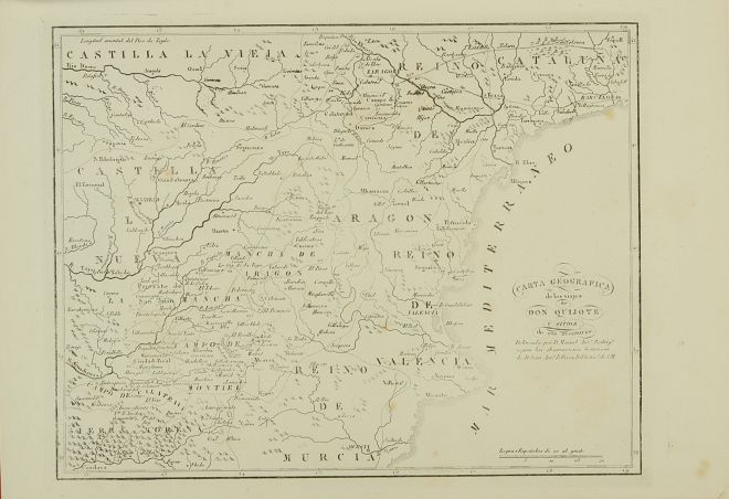
| Image | 1880-Barcelona-Espasa-02-085-m |
| Illustration No. | 1 |
| Illustrator | Manuel Antonio Rodríguez (copied after) |
| Engraver | Unknown |
| Lithographer | |
| Title Caption | CARTA GEOGRAFICA de los viajes de DON QUIJOTE Y SITIOS de sus aventuras |
| Title Supplied | |
| Part | |
| Chapter | |
| Subject | |
| Illustration Type |
Map |
| Technique |
Burin engraving |
| Color | Black and white |
| Volume | II |
| Page Number | f.p. 566 |
| Image Dimension | 210 x 270 |
| Page Dimension | 240 x 340 |
| Commentary | The map has been done "según las observaciones históricas de D. Juan Antonio Pellicer, Bibliotecario de S. M.".
It includes "INDICACION DE LOS SITIOS Y AVENTURAS Á QUE SE REFIEREN LOS NUMEROS CONTENIDOS EN ESTE MAPA" (p. 566). First sally: 1 - 4; second sally: 5 - 16; third sally: 17 - 45. |
| Notes | 1 - It is a copy of the map appeared in Madrid: Sancha, 1797 - 1798 and Madrid: Sancha, 1798 - 1799. Now, the references to places and adventures do not appear inside the map. |