click to enlarge
Burin engraving
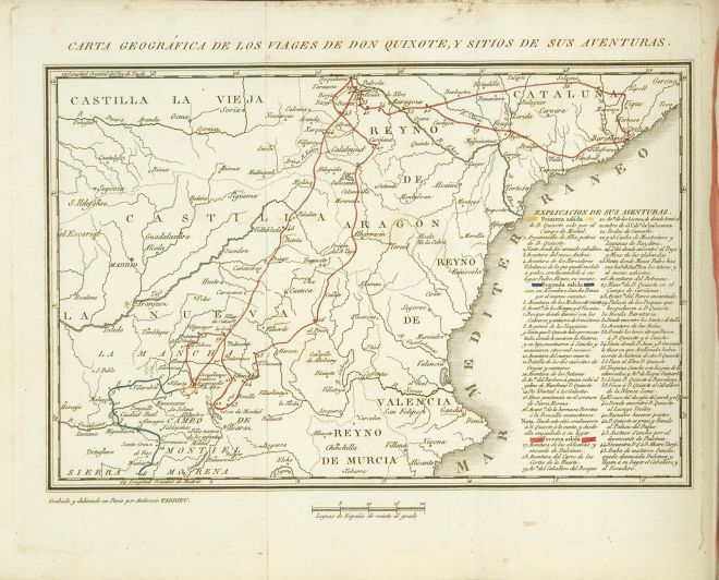
Route of first sally colored in yellow (1 - 4); second sally colored in blue (5 - 16); third sally colored in red (17 - 45).
Excellent engraving.
|
click to enlarge |
|
| Image | 1814-Paris-Masson-02-001-m |
| Illustration No. | 1 |
| Illustrator | Ambrosio Tardieu |
| Engraver | Ambrosio Tardieu |
| Lithographer | |
| Title Caption | CARTA GEOGRÁFICA DE LOS VIAGES DE DON QUIXOTE, Y SITIOS DE SUS AVENTURAS. |
| Title Supplied | |
| Part | |
| Chapter | |
| Subject | |
| Illustration Type |
Map |
| Technique |
Etching (acquaforte) Burin engraving |
| Color | Colored |
| Volume | II |
| Page Number | f.p. 1 |
| Image Dimension | 147 x 221 |
| Page Dimension | 200 x 262 |
| Commentary | Map with a portion of Spain (central and East) including 45 points of don Quixote's route (10 more than in Madrid: Ibarra, 1780) accompanied by an "EXPLICACION DE SUS AVENTURAS".
Route of first sally colored in yellow (1 - 4); second sally colored in blue (5 - 16); third sally colored in red (17 - 45). Excellent engraving. |
| Notes | 1 - Based on the "MAPA DE UNA PORCION DEL REYNO DE ESPAÑA QUE COMPRENDE LOS PARAGES POR DONDE ANDUVO DON QUIXOTE Y LOS SITIOS DE SUS AVENTURAS" designed by Tomás López, geographer of His Majesty, according to the observations done on the spot by José de Hermosilla, captain of engineers for Madrid: Ibarra, 1780 (also in Madrid: Ibarra, 1782). |