click to enlarge
Map
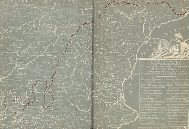
Over the map legend, don Quixote's arms: barber basin (Mambrino's helmet), armour, shield of the Knight of the sad countenance, shield with a lion...
|
click to enlarge |
|
| Image | 1961-Barcelona-Marin-01-001-e |
| Illustration No. | 1 |
| Illustrator | Tomás López |
| Engraver | |
| Lithographer | |
| Title Caption | MAPA DE UNA PORCION DEL REYNO DE ESPAÑA QUE COMPREHENDE LOS PARAGES POR DONDE ANDUVO DON QUIXOTE, Y LOS SITIOS DE SUS AVENTURAS |
| Title Supplied | |
| Part | |
| Chapter | |
| Subject | |
| Illustration Type |
End papers Map |
| Technique |
Process / Photomechanical technique |
| Color | Black and white |
| Volume | I |
| Page Number | End papers |
| Image Dimension | 280 x 400 |
| Page Dimension | 280 x 400 |
| Commentary | Map with a portion of Spain (central and East) including 35 points of don Quixote's route (since the inn where he was knighted); first sally (4), second sally (12), third sally (19).
Over the map legend, don Quixote's arms: barber basin (Mambrino's helmet), armour, shield of the Knight of the sad countenance, shield with a lion... |
| Notes | 1 - Photomechanical reproduction of the map first appeared in Madrid: Ibarra, 1780. |