click to enlarge
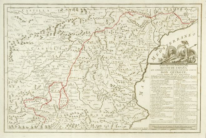
Over the map legend, don Quixote's arms: barber basin (Mambrino's helmet), armour, shield of the Knight of the sad countenance, shield with a lion...
2 - The route has been hand colored in red.
|
click to enlarge |
|
| Image | 1780-Madrid-Ibarra-01-010-m |
| Illustration No. | 1 |
| Illustrator | Tomás López |
| Engraver | Tomás López / Manuel Salvador Carmona |
| Lithographer | |
| Title Caption | MAPA DE UNA PORCION DEL REYNO DE ESPAÑA QUE COMPREHENDE LOS PARAGES POR DONDE ANDUVO DON QUIXOTE Y LOS SITIOS DE SUS AVENTURAS |
| Title Supplied | |
| Part | |
| Chapter | |
| Subject | |
| Illustration Type |
Map |
| Technique |
Burin engraving |
| Color | Black and white |
| Volume | I |
| Page Number | f.p. 196 |
| Image Dimension | 277 x 423 |
| Page Dimension | 342 x 466 |
| Commentary | Map with a portion of Spain (central and East) including 35 points of don Quixote's route (since the inn where he was knighted); first sally (4), second sally (12), third sally (19).
Over the map legend, don Quixote's arms: barber basin (Mambrino's helmet), armour, shield of the Knight of the sad countenance, shield with a lion... |
| Notes | 1 - The map was designed by Tomás López, geographer of His Majesty, according to the observations done on the spot by José de Hermosilla, captain of engineers.
2 - The route has been hand colored in red. |