click to enlarge
|
| 1826-Paris-Bossange-02-004-m |
|
1
|
|
François Cosnier (after Ambrosio Tardieu)
|
|
|
|
François Cosnier
|
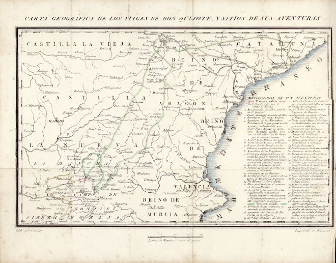
| CARTA GEOGRÁFICA DE LOS VIAGES DE DON QUIXOTE, Y SITIOS DE SUS AVENTURAS. |
| |
|
|
| |
|
|
Map
|
Lithography
|
| Colored |
| II |
| f.p. 1 |
| 147 x 230 |
| 195 x 245 |
Map with a portion of Spain (central and East) including 45 points of don Quixote's route (10 more than in Madrid: Ibarra, 1780) accompanied by an "ESPLICACION DE SUS AVENTURAS".
Route of first sally colored in pink (1 - 4); second sally colored in yellow (5 - 16); third sally colored in green (17 - 45).
Excellent lithograph imitating engraving. |
1 - Based on the "MAPA DE UNA PORCION DEL REYNO DE ESPAÑA QUE COMPRENDE LOS PARAGES POR DONDE ANDUVO DON QUIXOTE Y LOS SITIOS DE SUS AVENTURAS" designed by Tomás López, geographer of His Majesty, according to the observations done on the spot by José de Hermosilla, captain of engineers for Madrid: Ibarra, 1780 (also in Madrid: Ibarra, 1782).
2 - Copied after the map published in Paris/London: Bossange y Masson, 1814. |