Image 1798Madrid-Sancha-08-004-m 
Illustration No. 1     
Illustrator Manuel Antonio Rodríguez 
Engraver Unknown 
Lithographer  
Title Caption CARTA GEOGRÁFICA DE LOS VIAGES DE DON QUIXOTE Y SITIOS DE SUS AVENTURAS 
Title Supplied  
Part  
Chapter  
Subject  
Illustration Type Map
 
Technique Burin engraving
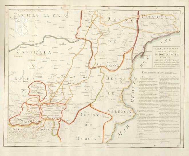
Etching (acquaforte)
 
Color Colored 
Volume VIII 
Page Number f.p. 342 
Image Dimension 286 x 364 
Page Dimension 324 x 394 
Commentary First sally: 1 - 4 (since Argamasilla de Alba); second sally: 5 - 16; third sally: 17 - 45.
Marked in red: Priorato de San Juan, Campo de Montiel, Campo de Calatrava, Reino de Murcia and Reino de Aragón.
Marked in light yellow: Reino de Valencia and Sierra Morena.
Marked in maroon: Cataluña and Castilla La Vieja.
Marked in blue: Lagunas de Ruidera and Mediterranean coast.
Marked in green: Castilla La Nueva.
Marked in dark yellow: Don Quixote's route. 
Notes 1 - "Según las observaciones históricas de D. Juan Antonio Pellicer, bibliotecario de S. M."
2 - This map first appeared in Madrid: Sancha, 1797 - 1798; the colors in both maps change.